

Mystery solved: How the Egyptians built pyramids in the middle of a desert

The pyramids of Giza stand tall in Egypt. They are surrounded by miles and miles of desert land. They are located in the middle of an inhospitable landscape. The yellow sands around them stretch for as long as the eye can see. Whether you are a tourist standing in front of these pyramids or a researcher of Egyptian history, you are bound to wonder -
How on earth did those ancient Egyptians get the huge stones used in the pyramids to the middle of this desert? How did they transport massive blocks of limestone across long stretches of sand? Camels could not have carried heavy slabs of granite and limestone on their backs (esp. across so many miles of nothingness)? How exactly did they manage to build these?

These structures may look a little small in photos (such as the ones above). We should remember that the Great Pyramid had remained the tallest and the biggest structure on earth for almost 4 thousand years (until the Eiffel tower came along 130 years ago).
Trivia 1: The Great Pyramid weighs about 6 MILLION TONNES (that’s equal to the weight of ONE MILLION ELEPHANTS put together)
Trivia 2: The granite stones used in the Great Pyramid were brought from a place called Aswan that is ~900km away from Giza.
Trivia 3: The Great Pyramid used to be shiny. Today, you'll see somewhat blackened stones surrounded by smog and sand. 4,000 years ago, it used to sparkle in the night. The pyramid was covered in polished limestone.
In the middle of yellow sands
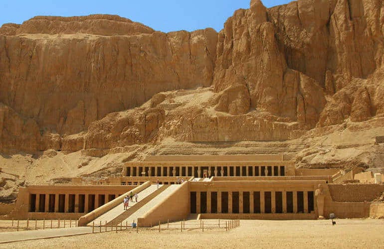
Not only are the pyramids of Giza located in the middle of a vast desert land, even the temples in the Valley of Kings and the Valley of Queens are surrounded by yellow sands and nothingness. Researchers were not just puzzled by how the Giza pyramids had been constructed. They were curious about how almost all giant structures in Egypt had been constructed in the middle of nowhere. What engineering marvel did the ancient Egyptians use to transport such heavy stones across the desert sands?
Hypothesis 1 - a long dried river?
For many decades, researchers hypothesized that the river Nile should have been used to transport the large blocks of stone. However, the Nile flows at a vast distance away from the temples and pyramids today. It would be too much of a distance for camels / carts to carry these stones to the pyramid from where the Nile flows today.
So, one of the possible solutions was that the Nile river used to flow closer to the pyramids, OR, that the river had a channel that flowed closer to the pyramids. But this was just a hypothesis. Proof needed to be found.
Proof 1: A dig shows a harbour
A few years ago, when archaeologists had dug near the pyramids and the temples, they found that several of these structures led to harbours near them (they stay buried underground now). For example, the harbour of the Great Pyramid is quite close to the town of Gaza. Archaeologists also found remnants of ancient boats, tools and structural remains of a port city in Gaza.
Trivia: The archaeological dig also showed charcoal remains of trees (e.g. cedar, juniper, pine and oak). While Gaza is a part of a desert today, it must have been a rich and green farmland with giant trees growing overland.
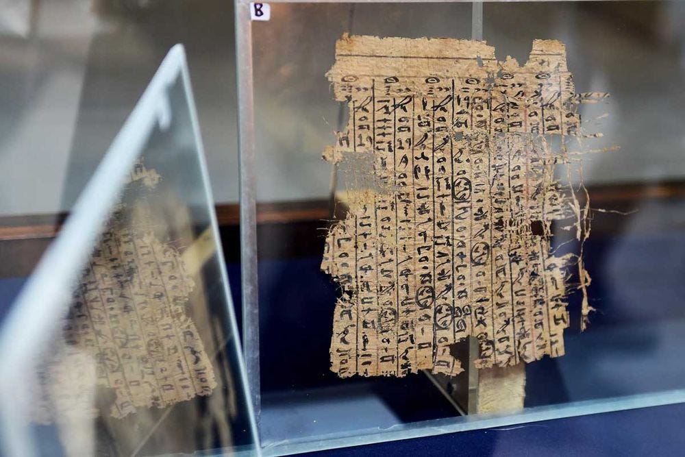
Proof 2: A papyrus turns up
Another archeological excavation found an ancient papyrus scroll. This was the oldest known Egyptian papyrus - the diary of a man called Merer.
Who was Merer? What did his logbook / diary contain?
Merer was employed in the government of Egypt, about 4000 years ago. He was an officer in charge of a team that was engaged in constructing a pyramid. His team was responsible to transport limestone blocs from the quarry of Tura to the construction site of the great pyramid of Khufu at Giza. Luckily for us, Merer would end his day with a diary / logbook of all that he had done that day.
Included in his logbook were -
That giant blocks of stone had been brought upto the site of the pyramid by boats.
About every ten days, two or three round trips were done, shipping perhaps 30 blocks of 2–3 tonnes each, amounting to 200 blocks per month.
About forty boatmen worked under him.
The period covered in the papyri extends from July to November."
The proofs were getting better. Researchers were rubbing their hands in glee. All that was left was to find exactly where this river used to flow. There had to be incontrovertible proof.
The Final Proof (no. 3): Satellite and Radar data + soil samples
By now, everyone knew that a river must have been in proximity. But nobody knew what its shape was, how big it was, and where it ran. Dr. Eman Ghoneim (a researcher who hails from Egypt, but now works in the USA) tried to take a crack at solving this puzzle. She saw that a satellite image of the soil beneath a small part of Egypt showed evidence of an unmarked riverbank. She set out to investigate further.
She continued to collect satellite images of sections of the land near the pyramids and the temples. She also collected soil samples from different locations. These samples were evaluated to see if there were traces of long dead plants / trees.
Her team wanted to find how the ground looked beneath the desert lands near the pyramids. One could not go about digging deep at random locations, without causing disruption to people and structures around. So her team used an instrument called ‘Ground Penetrating Radar’ - this is a device that sends out radio waves into the ground and based on the feedback it receives, the instrument creates a picture of what the ground beneath looks like.
When taken together (the soil samples, the images from the ground penetrating radar and satellite images), they were able to piece together the puzzle. A channel of the river Nile had indeed flown very close to the pyramids. They called this newly discovered branch ‘Ahramat’. In Egyptian, the word Ahramat means ‘pyramid’.
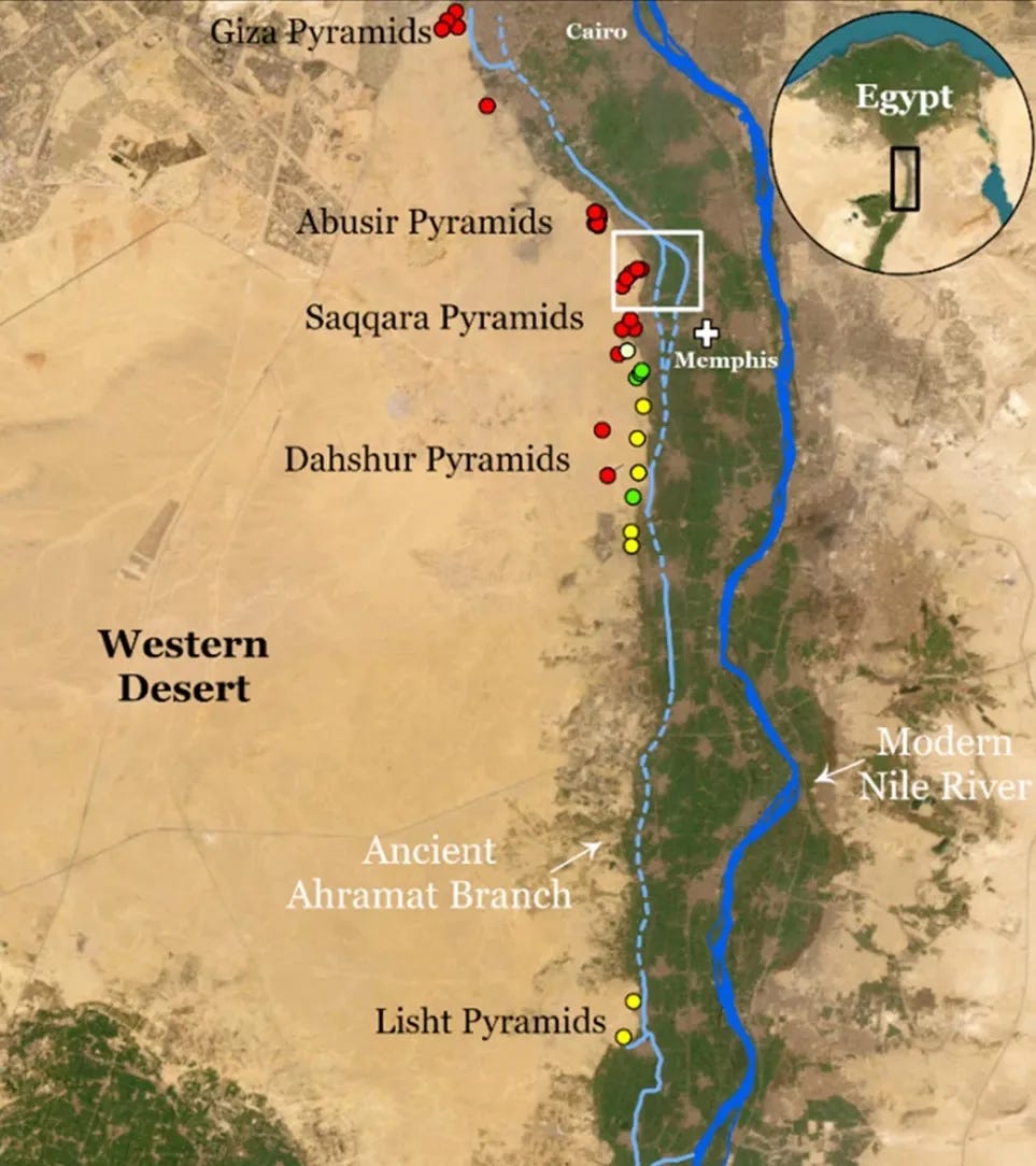
The Ahramat clearly ran very close to the pyramids - which means that it had acted as a highway for the transport of building materials (~4000 years ago).
When the pyramids were built, Egypt looked very very different from what it is today. By finding where the Nile must have flown and by re-creating these images, we are able to understand today how the ancient Egyptians used the natural environment around them to transport building materials to the site for the construction of the pyramids.
I was quite excited when I read about this piece of scientific research a few weeks ago. I hoped you enjoyed reading about it. If you have friends who love reading and are curious by nature, definitely share this article with them, by clicking the button below.
Interesting podcasts to listen to
(a) A tiger reserve in India has received a special certification. This special status makes it great fun for kids to visit the reserve and stay up all night. Guess why?
(b) Looking for a new book to read? Black Beauty by Anna Sewell is a delight for anyone older than 9. Want to find out what other kids have to say about the book?
(c ) Want to travel to Egypt? A family of three had traveled there recently and they shared their experiences of the trip here. This is from our travel channel ‘Misadventures of a Sneaker’. You can also read their itinerary details here.
Source articles
a) Book published about the logbook of Meher
b) Dr.Ghoneim’s interview - Smithsonian Magazine
c) Researchers around the world are excited by this - Live Science
d) The complete research of Dr.Ghoneim and her team - Nature